
The Greenland agreement secures, for an indefinite duration, the island that hosts one radar. The reason that single radar justifies a treaty is visible only when the whole sensor map is laid out at once: Pituffik is the middle node of a three-site arc, the northern anchor of a layered architecture, and the one node whose geography cannot be replicated anywhere else in allied territory. Drawing the full map, from California to Yorkshire to the Aleutians to the new Canadian over-the-horizon sites, explains both what each radar does and why the modernisation now funded is shaped the way it is. The complete inventory, every radar and constellation counted with its status, is in our sensor map.
The geometry that assigns every site its job
One calculation governs the whole map. A radar's line of sight to a target shrinks with the target's altitude, following the Earth's curve: against an object at ballistic apogee, thousands of kilometres; against a sea-skimming cruise missile, about 11 kilometres. The chart below is that geometry, and every siting decision in the network's history is an answer to it.
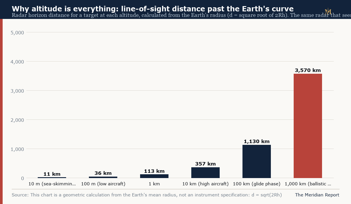
High-arcing ballistic weapons are visible from enormous range, but only if a radar sits under the arc. Low-flying weapons vanish over the curve close to any given radar, but a chain of radars, or a radar that bends its signal off the ionosphere, can close the gap. The network, old and new, is a set of positions chosen so that every trajectory a hostile weapon can fly passes within somebody's line of sight, and every modernisation programme is an attempt to shrink the spaces between.
The three-node arc
The solid state phased array system at the heart of North American warning runs three Upgraded Early Warning Radars on a great-circle arc, and each faces a different set of corridors.
Pituffik, Greenland, the arc's northern node, 750 miles north of the Arctic Circle, faces the pole. Its AN/FPS-132 radar watches the corridors between Asia and North America over the Arctic, the shortest ballistic paths, and contributes space surveillance over the same geography. It is the only US node positioned for that geometry, which is a fact about the rotating Earth and the great circles, not about politics: no site in the contiguous United States or western Europe sees what Pituffik sees.
RAF Fylingdales, North Yorkshire, the eastern node, faces the Atlantic approaches. Its mission, per the RAF's own description, is continuous ballistic missile early warning for the United Kingdom and the United States, with coverage oriented toward launches whose trajectories cross the North Atlantic toward Europe and the eastern seaboard. It is also part of the space surveillance network, tracking objects in near-earth orbit out to around 3,000 nautical miles.
Beale Air Force Base, California, the southern and western node, covers the Pacific approaches, the long arcs from Asia that come over the pole and down the Pacific, and supports the west coast's defences. Its radar was among the first upgraded in the SSPARS modernisation, and it anchors the arc's other end.
The arc's logic is coverage by geometry: between the three, the elevated trajectories that a missile launched anywhere in Asia, the Middle East or Europe would follow toward North America cross at least one node's field of view in time to be tracked, culled and handed to the defences. Remove any node and a set of corridors goes dark; this is why the network has survived every administration change since 1960, and why an agreement securing the Greenland node's host island matters at the level of architecture rather than politics.
The Alaska layer: discrimination, not just detection
Detection is the arc's job; discrimination happens further down the track, and Alaska hosts it. Cobra Dane on Shemya Island, in the Aleutians, a long-range phased array with a published detection range of about 2,000 miles, has spent four decades doing intelligence-collection and tracking on objects crossing the Pacific, and it remains part of the missile defence sensor network. The newer and much larger layer is the Long Range Discrimination Radar at Clear Space Force Station in central Alaska, designed as the lead sensor of a new class optimised to identify threat objects in complex countermeasure environments, and it reached operational acceptance in December 2025. Together with the sea-based X-band radar concept it was designed to complement, the Alaska pair sits under the Pacific midcourse: their task is to look at the cloud of objects a missile releases in space, and separate the warheads from the decoys, so that the ground-based interceptors at Fort Greely, Alaska and Vandenberg, California fire at the right things.
The distinction between the arc and the Alaska layer is the network's division of labour: the three Upgraded Early Warning Radars warn, wide and fast; the Alaska radars classify, deep and precise. The handoff between them, track data flowing from the first to focus the second, is the kill chain's opening segment, and the December 2025 acceptance of LRDR completed a build-out the Missile Defense Agency has pursued since the mid-2010s.
The Canada layer: the low-altitude problem
Everything above watches altitudes where the geometry is generous. The layer being built now addresses the geometry that is not. Canada's C$38.6 billion, twenty-year NORAD modernisation plan, announced in 2022, puts its largest single bet on over-the-horizon radar: a system modelled on Australia's Jindalee Operational Radar Network, adapted with Australian partnership for Arctic conditions, that bounces high-frequency signals off the ionosphere to detect aircraft and missiles at thousands of kilometres, past the curve that blinds line-of-sight radar. Its published target is cruise-missile-scale detection out to hundreds of kilometres against low fliers, precisely the corridor-flying threat that the North Warning System's short-range radars, some three dozen unattended units strung across the high Arctic alongside the long-range AN/FPS-117s, cannot see far enough to matter against. Work on Canada's first Arctic over-the-horizon sites is expected to begin in 2026, with the North Warning System itself maintained and its most exposed stations being rebuilt under a US Air Force contract awarded in May 2026. The physics behind the ionospheric layer, and the forty year Australian record it draws on, are in our guide to over-the-horizon radar.
The Canadian layer and the American arc are complementary by design: the over-the-horizon sites watch low and wide across the polar approaches, the NWS and Pituffik hold the line-of-sight missions, and the space layer, below, takes the mission neither can hold.
The space layer: custody above the curve
Infrared satellites detect launches from orbit, the veteran DSP constellation's successors in the SBIRS system provided that warning for two decades, and the Next-Gen OPIR constellation, now in delivery after its first GEO satellite passed environmental testing in 2025, is designed for faster-burning and more elusive boosts. Launch detection is the network's opening bell, and it comes from space regardless of where the missile is headed.
The newer space mission is custody through flight. The Space Development Agency's proliferated tracking constellations, many small satellites rather than a few large ones, carry infrared sensors designed to track hypersonic glide vehicles, which fly below ballistic apogees and manoeuvre, through their entire flight path. The Hypersonic and Ballistic Tracking Space Sensor, demonstrated on orbit, adds fire-control-quality tracking, data good enough to aim an interceptor. In July 2026, SDA contracted for additional tracking satellites derived directly from the HBTSS design under the Golden Dome programme, and the Greenland agreement's preamble names that programme in the treaty text itself. The signal is architectural: the American homeland-defence buildout now formally includes Greenland's geography as a component, not merely a location.
What the modernisation adds up to
Set the layers side by side and the rebuild's shape is legible. Space detects launches and, increasingly, holds custody through glide. Over-the-horizon radar in Canada covers the low-and-wide corridor flying that line-of-sight radar cannot. The three-node arc, Beale, Fylingdales, Pituffik, holds the ballistic warning mission its geometry was built for, with Pituffik's modernisation secured by the new agreement. The Alaska discrimination layer classifies what the interceptors must engage. Every layer fills a blindness in the others, and the money flows accordingly: Canadian billions into over-the-horizon, American billions into space tracking and the Clear and Pituffik ground segments.
The Greenland agreement's place in that structure is now precise. It does not add a radar, name a sensor or change the arc; what it does is convert the ground under the arc's irreplaceable northern node from a matter of negotiation into a matter of treaty, for an indefinite duration, with the homeland-defence mission named in the preamble. The physics of the map explains why the node is worth that instrument: the corridors Pituffik watches cannot be watched from anywhere else the alliance holds, and every layer above and below depends on the warning the arc's middle provides first. Our coverage of the signed agreement, the capability it enables, the threat physics behind the rebuild and the ratification path tracks the instrument; the map above is the machine it attaches to.