
One sentence in the Danish Foreign Ministry's summary of the signed Greenland agreement does most of the work the sovereignty argument has been shouting over: the United States may modernise and enlarge Pituffik Space Base, and establish new defence areas at Narsarsuaq and Mestersvig. Everything else in the deal, the free movement across the island and its territorial waters, the overflight and landing rights anywhere on the island, exists to serve that sentence. This is an infrastructure agreement for the radar mission, and reading it that way explains both why Washington wanted it and why the base it will rebuild is a shadow of what once stood there.
The radar at the top of the map, and what it watches
Pituffik, 750 miles north of the Arctic Circle, operates an Upgraded Early Warning Radar, the AN/FPS-132: a solid state phased array whose face carries 3,589 antenna elements, with detection range measured in thousands of miles, around 3,000 by published accounts. The US Space Force assigns the base three missions: missile warning, missile defence and space surveillance. The 12th Space Warning Squadron operates the radar as part of the Integrated Tactical Warning and Attack Assessment network, the system that would detect a ballistic missile launch toward North America in its first minutes of flight.
Geography is the whole point. The shortest ballistic missile trajectories between Asia and North America cross the Arctic, which is why the United States built its northern warning line across Greenland, Alaska and the United Kingdom in the early Cold War and has never closed the Greenland node. Every upgrade to that radar, and every expansion of the infrastructure that supports it, is an upgrade to the amount of warning time North America has. That single fact, not minerals and not symbolism, is the capability logic of seventy five years of American presence on the island.
Space surveillance is the quieter half of the mission. The same installation tracks objects in orbit over the pole, feeding the network that catalogues satellites and debris. As both the American and Chinese constellations multiply and as polar orbits grow more crowded, the northern sensor's role in that catalogue grows with them.
The deal's terms, translated into capability
The signed terms do three concrete things for the sensor mission.
The first change is modernisation and enlargement at Pituffik itself. The base's radar is a known quantity with a published capability envelope; what constrains the mission is the infrastructure underneath it, power, housing, runways, fuel, and the workforce to sustain all of it. The construction record shows the build-up began years before the deal: roughly 384 million dollars of construction executed since 2016, including dormitory recapitalisation and a new civil engineer facility, with airfield improvement projects of up to 25 million dollars solicited in January 2026. The agreement converts that piecemeal programme into a right, removing the permission friction that a modernisation campaign would otherwise hit at every step.
The second is two new defence areas in the places the Cold War network already used. Narsarsuaq, in the south, is the WWII-era Bluie West One airfield, built by the United States in 1941 as the ferry route's stepping stone, closed as a base in 1958 and handed to civilian use. Mestersvig, in the northeast, served the network of wartime and Cold War outposts on the eastern coast. Re-establishing defence areas at the two historical nodes gives the American military redundancy and reach that a single northern base cannot provide: an alternate airfield in the south, a presence on the east coast facing the Greenland and Norwegian seas, and route structure between them.
Third, movement. Free access between defence areas, including in territorial waters, by land, air and sea, plus overflight and landing rights anywhere on the island, is what turns two or three fixed sites into a network. Radar, communications relay, logistics and search-and-rescue all depend on the ability to move equipment and people between points without negotiating each transit. In capability terms, this clause is worth as much as the construction rights.
What the deal does not do
The published terms contain no interceptor deployment, no offensive weapons and no new sensor system. The announced content is modernisation of an existing radar site, two defence areas whose facilities will take years to build, and movement rights. The distinction matters because commentary since the announcement has oscillated between the deal as a sovereignty event and the deal as a weapons deployment. It is neither, on the evidence. It is the legal scaffolding for a construction programme, and the programme's schedule, not the signature, will determine when any capability actually changes.
One scope note: the published text, released by the White House on 22 September, frames its capability content as objectives and permissions rather than construction schedules. Article IV names the modernisation of Pituffik and the new defence areas at Narsarsuaq and Mestersvig, with modalities still to be mutually agreed, and the preamble makes the United States' access to Greenland necessary to the defence of the treaty area, Greenland, and the American continent, including, in the treaty's own words, through establishment of a Golden Dome defence system. That is the first explicit treaty-level linkage of Greenland to the American missile defence architecture programme. What the text does not contain is a timeline, a budget or a sensor specification, so the capability reading rests on the programme record above, not on the instrument's own schedule. Our full breakdown of what the Golden Dome programme consists of, and what it can and cannot intercept, is here.
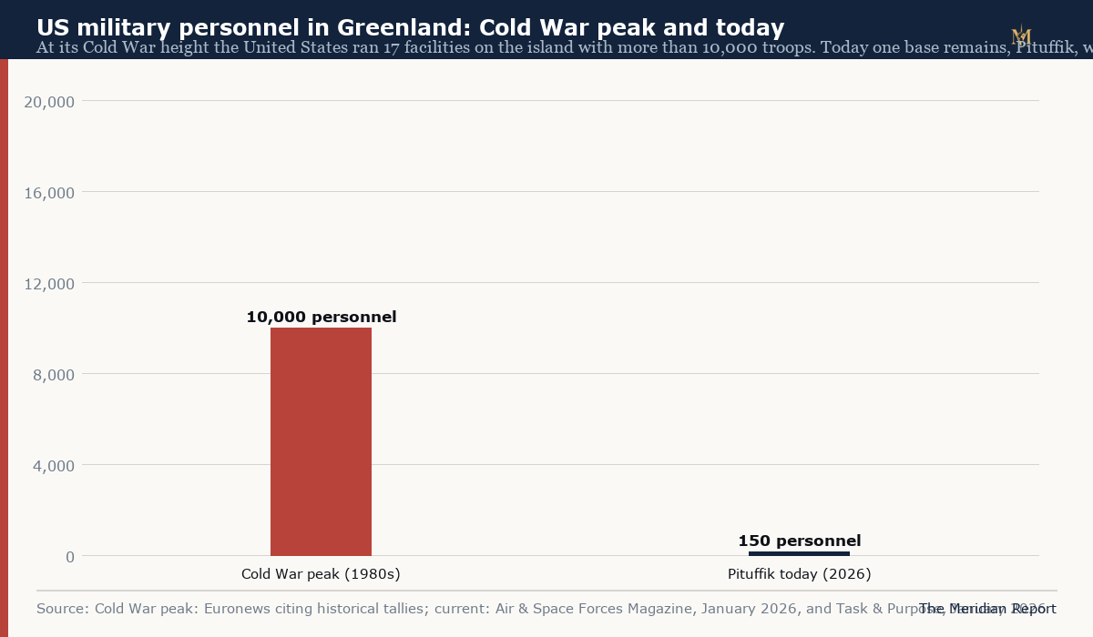
The gap the rebuild addresses
The chart above is the strategic story in two bars. At its Cold War height, the American position on Greenland was a distributed system: 17 facilities, more than 10,000 personnel, the DEW Line's Greenland segments, Nike missile batteries near the base, and the full Bluie network of airfields and weather stations. What survives today is one base with roughly 150 uniformed personnel and a contractor-operated support structure, extremely capable at its single sensor task and thin at everything around it.
The rebuild logic follows from that shape. A modernised radar with a decaying base cannot sustain surge operations, wartime manning or the logistics load of new construction. The dormitory, runway and utility work already under way, and the enlargement the deal now enables, are the unglamorous prerequisites of the mission the base exists for. Narsarsuaq and Mestersvig are the same logic applied to geography: the Cold War network was distributed because a single point fails, and the new defence areas restore redundancy seven decades later.
What the deal does not restore is the human scale. Nothing in the published terms suggests a return to a five-digit garrison; the modern American model is small uniformed crews plus contractors plus construction surges. The 150 personnel at Pituffik may grow, but the capability the deal targets is measured in sensors, sorties and warning minutes, not headcount.
Why this, why now
Three trends converged to make a 1951-era radar base the object of a sovereignty-scale negotiation. Arctic ice retreat has opened the northern approaches that the radar watches, increasing both civil and military traffic over the pole. Strategic competition has returned to the High North, with Russian long-range activity and Chinese polar presence rebuilding the threat picture the early warning network was designed for. And the missile warning mission itself has grown heavier: hypersonic and cruise threats, denser satellite traffic and the modernisation of NORAD's sensor architecture all push toward more capable northern infrastructure.
The Greenland agreement, read as an infrastructure document, is the American answer to that convergence: secure permanent, low-friction access to the island's geography, rebuild and distribute the physical plant, and keep the radar at the top of the map watching the pole. The sovereignty argument, which our main analysis tracks in detail, is the argument the signing produced; the capability this explainer describes is the purpose the construction will serve. The first is now settled. The second is a schedule measured in years, and its milestones, not the ceremony in New York, are what to verify from here.