
Every missile warning system ever built answers one question: how much time is there between seeing a launch and the arrival of what was launched. The answer determines everything downstream, how many minutes civil authorities have, how many chances an interceptor has, how far forward a sensor must sit. For seventy years that answer was governed by the physics of ballistic flight, and the radar line across the Arctic exists because ballistic physics is generous to the defender. The new generation of weapons is built on physics that is not, and the multi-billion-dollar rebuild of North American aerospace warning now under way is the direct consequence. Understanding what changed means starting with the curve of the Earth.
The geometry that built the Arctic line
A ballistic missile spends most of its flight in space. Launched on a great-circle arc toward North America, it climbs above the atmosphere, coasts through apogee at altitudes above 1,000 kilometres, and descends along a path that is, from the moment the booster burns out, almost entirely predictable: a parabola written in gravity. Predictability is the defender's gift. A radar that catches the object at any point on that arc can compute where the arc ends, which is why early warning radars do not need to be everywhere. They need to be positioned so that the high arc passes over their horizon.
But a radar cannot see through the Earth. Line of sight to a target at altitude is a geometry problem: the higher the target flies, the further away it can be seen past the curve. Against a ballistic missile at apogee, that line of sight runs thousands of kilometres. Against an aircraft or cruise missile flying a few hundred metres above the surface, it collapses to tens of kilometres, about 50 miles from a low-flying target, in the Air & Space Forces Magazine's account of the physics that shaped NORAD. The Cold War answer to that geometry was to build a line of radars across the high Arctic, the Distant Early Warning Line, later the North Warning System, so that nothing flying the polar approach could reach North American airspace unwarned. Today's system, roughly a dozen long-range AN/FPS-117 radars and some three dozen short-range units across northern Canada, with the AN/FPS-132 at Pituffik watching the high arcs from Greenland, is that logic, maintained.
The Arctic line was designed for two kinds of threat: bombers, and ballistic missiles on high arcs. Both are visible to it by geometry. The weapons now entering service are designed around the same geometry, from the other side.
What hypersonic glide vehicles do to the model
A hypersonic glide vehicle is launched on a rocket like a ballistic missile, which means the launch is detectable, the United States and its partners see boosts from space today just as they have since the 1960s. The divergence comes at boost burnout. Instead of continuing on the ballistic arc, the glider separates and flies within the upper atmosphere, on a lifting trajectory at altitudes the published modelling puts in the tens of kilometres, roughly an order of magnitude below a ballistic apogee, manoeuvring as it goes.
That profile attacks the warning architecture at both ends at once. At the sensor end, the glider spends its flight below the line of sight that makes high-arcing ballistic objects visible at range; ground radars see it late, and only once it is already close, because the Earth's curve has hidden it for most of its journey. At the prediction end, manoeuvring destroys the parabola: a ballistic track computes the impact point from physics, a glide track does not, so even a detected glider raises questions a ballistic track does not, where is it going, what is it aiming at, what does the defence engage it with. The flight is also fast, at or above Mach 5, so the warning time recovered by seeing the launch is consumed by a terminal phase that arrives without the long, legible descent ballistic defence was built around.
Cruise weapons change the picture by the opposite route. A modern low-observable cruise missile flies no faster than an airliner, but it flies the whole route low, using terrain to stay under the radar horizon for as long as the geometry allows. Against the short-range radars of the North Warning System, whose line of sight against a low flier is measured in tens of kilometres, a cruise route through the Arctic approaches is a sequence of invisible corridors. The threat is not speed but concealment, and the sensor answer is not a faster radar but a differently positioned one.
The scale of what the sensors must now handle
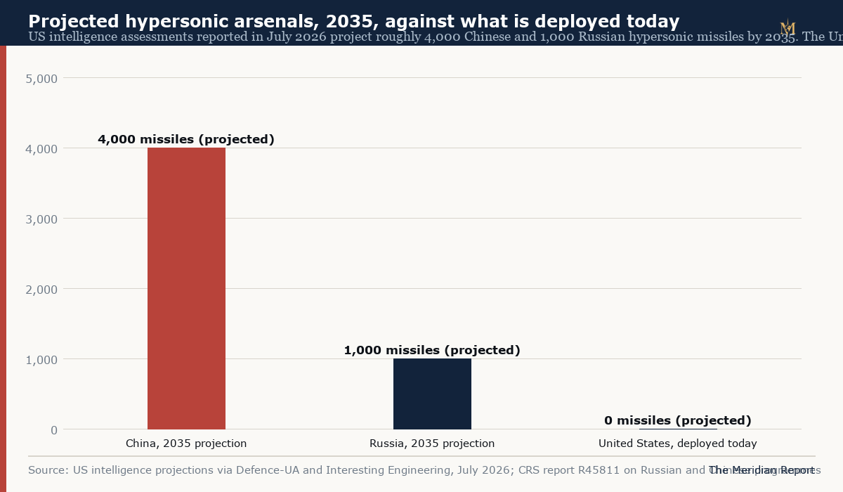
The arsenal projections behind the rebuild are public. Congressional testimony and intelligence assessments reported in July 2026 put the Chinese hypersonic inventory on a path to roughly 4,000 weapons by 2035, with Russia around 1,000, growth measured in multiples from today's deployed forces, and the Congressional Research Service's standing report on hypersonic weapons tracks the programmes behind those numbers, Russia's Avangard glider and Tsirkon, the air-launched Kinzhal, China's DF-17 and DF-27 families. The United States, notably, has no operational hypersonic missile of its own yet; its Dark Eagle ground-launched system remains in development. The asymmetry in warning requirements is sharper than the asymmetry in arsenals: the American homeland is the target set, so American and Canadian sensors must carry the full load of seeing whatever comes.
The new architecture: four answers to the same geometry problem
The modernisation now funded and under construction is best understood as four different answers to the same geometric problem, each covering a layer the other cannot.
The first answer is over-the-horizon radar. Rather than accept the Earth's curve, bend the signal over it: high-frequency radar bounced off the ionosphere sees targets at thousands of kilometres, including low fliers that line-of-sight radar cannot reach. Canada's Arctic over-the-horizon radar, part of the C$38.6 billion, twenty-year NORAD modernisation plan announced in 2022, is built on the design lineage of Australia's Jindalee Operational Radar Network, with the two countries partnering on adapting the system to Arctic conditions. Construction on Canada's first sites is expected to begin in 2026. The physics has a cost: ionospheric radar is imprecise by line-of-sight standards, better at warning than at fire control, which is why it is one layer among several. For the full story, from the ionosphere's behaviour to Jindalee's forty year record and Canada's government-to-government buy, see our dedicated guide.
The second answer is space, and it is the layer aimed squarely at the glide phase. A sensor above the atmosphere sees the glider's warm airframe against cold background continuously, without horizon geometry in the way. The Space Development Agency's Proliferated Warfighter Space Architecture distributes tracking sensors across large numbers of small satellites, and the Hypersonic and Ballistic Tracking Space Sensor programme, demonstrated on orbit, adds what the field calls fire-control-quality tracking: position and velocity data good enough to aim an interceptor, not merely to raise an alarm. In July 2026 the agency awarded contracts for additional tracking satellites derived directly from the HBTSS design, explicitly under the Golden Dome homeland-defence banner. A distributed low-orbit constellation also survives attrition in a way a few large satellites does not, which matters because the satellites doing the tracking would themselves be targets.
The third answer is to rebuild the terrestrial line for the threats that remain visible to it. The North Warning System is being maintained under contract and its most exposed radars are being rebuilt, with the US Air Force awarding a $40 million contract in May 2026 to reconstruct radar sites along the northern line, and Pituffik's AN/FPS-132, the upgraded early warning radar whose modernisation the Greenland agreement enables, remains the network's high-arc anchor. Line-of-sight radar against ballistic tracks is the one mission the new physics has not degraded, and the Arctic line still owns it.
The fourth answer is the interceptor and effector layer, which sits outside warning but defines what warning is for. The sensor chain's purpose is to buy the minutes that let a defence act, and the programme names attached to it, Golden Dome most prominently, are attempts to close the kill chain from the space track to the effector. The Greenland agreement's preamble, in its own words, recognises the shared interest in allowing the United States military access to Greenland's territory to defend the treaty area and the American continent, including through establishment of a Golden Dome defence system. The warning architecture and the basing geography have been formally joined in a signed instrument.
What this means for the Arctic radar map
The sensor geography that follows from the physics is legible. Line-of-sight radars, the North Warning System and Pituffik, keep the missions only they can do: high-arc ballistic warning, and close-in detection on the polar approaches. Over-the-horizon radar adds the wide, low view across approaches where cruise and air threats previously flew under the horizon, trading precision for reach. Space-based tracking takes the mission the ground was never going to hold, continuous custody of manoeuvring glide vehicles, and moves it above the atmosphere where custody is geometrically possible. Each layer exists because the other layers are blind to something, and the architecture as a whole is the first NORAD redesign since the Cold War that is organised around what the new weapons do to geometry rather than around counting warheads on arcs.
The Greenland agreement's place in that map is specific: the geography that hosts the northern anchor of the line-of-sight network, and that underwrites the routes and infrastructure any expansion of the ground segment would use, is now secured to the United States under an instrument of indefinite duration that names the homeland defence mission explicitly. Our analysis of what the signed agreement changes, the radar and space surveillance capability it enables, and the ratification path it must still clear cover the instrument itself. The physics explains why that instrument matters: warning time is the currency of homeland defence, the new weapons are engineered to spend that currency down, and every kilometre of Arctic geometry the sensors can see is how the defence buys it back.