
The network that watches for a missile on North America is not one system. It is a lattice of radars on the ice, phased arrays on three continents, infrared satellites in four orbits and a proliferated constellation now launching by the dozen, and no single number captures it. Count it by layer, though, and the map becomes legible: five big arrays for the first seeing, 54 small radars for the low gaps, three discrimination radars for the sorting, and a space layer whose on-orbit census changed three times this year. This page maps every sensor in that lattice, with what each one does, what it cannot do, and where the Greenland agreement now sits in it.
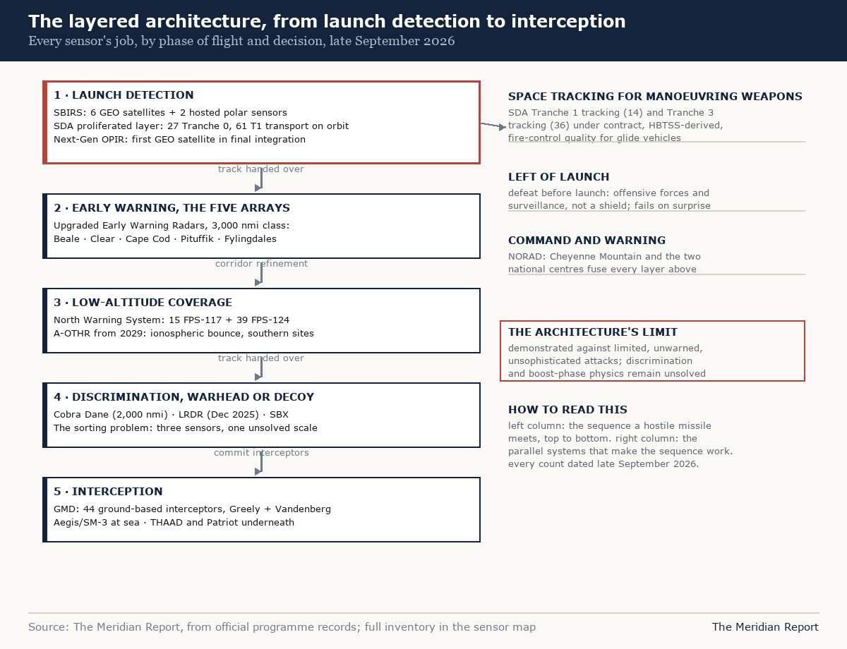
The first-seeing layer: five arrays on three continents
The network's anchors are five Upgraded Early Warning Radars, UHF phased arrays descended from the Cold War's Ballistic Missile Early Warning System, each capable of detecting a basketball-sized object at nearly 3,000 nautical miles:
Beale Space Force Station, California. The arc's Pacific node, watching the corridors between Asia and the American west, feeding both early warning and the missile defence tasking.
Clear Space Force Station, Alaska. The northern Pacific and Arctic node, upgraded to a three-faced phased array, contributing early warning while the newer Long Range Discrimination Radar beside it does the sorting.
Cape Cod Station, Massachusetts. The Atlantic node, watching the sea-launched corridors its PAVE PAWS ancestors were built for.
Pituffik Space Base, Greenland. The arc's northern node, 750 miles above the Arctic Circle, the only allied site whose geometry looks over the pole. The Greenland agreement signed on 22 September 2026 secures its modernisation and enlargement, and its preamble ties the base into the Golden Dome homeland defence architecture by name.
RAF Fylingdales, United Kingdom. The eastern node, three faces in a truncated pyramid, providing continuous ballistic missile early warning across the Atlantic approaches and near-earth orbit tracking to about 3,000 nautical miles, in Britain's own description.
Two faces give 240 degrees of coverage; Fylingdales' three give the full sweep. Between the five sites, every elevated trajectory from Asia, the Middle East or Europe crosses somebody's field of view in time to warn. That is the layer's whole job: first seeing, in minutes.
The low layer: 54 radars on the tundra
The arrays see things that climb. What they cannot see is what stays low, which is the geometry problem the North Warning System has watched since 1988. The NWS, the replacement for the Distant Early Warning line, consists of 15 long-range AN/FPS-117 radars and 39 short-range AN/FPS-124 radars, 36 of the short-range units in Canada and 3 in Alaska, unattended installations strung across the Arctic that watch the low-altitude corridors and feed both NORAD countries. Their radomes and electronics are aging, and the maintenance has become a programme of its own: in May 2026 the US Air Force awarded a roughly $40 million contract to rebuild the deteriorating radomes protecting the unattended low-altitude radars across northern Canada.
The low layer's next generation is already bought. Canada's Arctic Over-the-Horizon Radar programme, procured government-to-government from Australia's BAE Systems under the Jindalee design lineage and signed into its delivery phase on 22 June 2026, will bounce high-frequency signals off the ionosphere to watch the polar approaches from southern Canadian sites, with initial capability set for December 2029. It is the layer that closes the corridor the short-range radars could only watch piecemeal.
The sorting layer: telling warheads from decoys
Warning is useless to a defender if the interceptor cannot find the warhead, and midcourse space is full of decoys, chaff and debris. The sorting layer exists for the discrimination problem:
Cobra Dane, Eareckson Air Station, Shemya, Alaska. A single-faced L-band phased array, 95 feet in diameter, tracking objects to about 2,000 miles, built in 1977 to watch Soviet missile tests from the best vantage point in the Aleutians and upgraded into the missile defence mission in 2004. It collects the metric and signature data that make discrimination possible.
Long Range Discrimination Radar, Clear, Alaska. The GMD system's dedicated sorter, operationally accepted in December 2025 after years of construction, designed to hold the middle of the Pacific corridors and pass fire-control-quality tracks to the interceptors at Fort Greely.
Sea-Based X-Band Radar. The mobile, half-billion-dollar radar on a converted oil-drilling platform, positioned where a particular trajectory needs it, contributing the finest X-band resolution the system has.
The sorting layer is small, three principal sensors, and that smallness is the point of its criticism: discrimination at scale remains the hardest unsolved problem in missile defence, and the sensors that attempt it are few.
The space layer: the launch detectors and the trackers
Everything above depends on knowing a launch happened. The space layer provides that, and it is in mid-generation transition:
SBIRS, the Space Based Infrared System. Six dedicated satellites in geosynchronous orbit, all operational, plus two infrared sensors hosted on classified satellites in highly elliptical orbits watching the poles, the constellations that have provided America's missile launch warning for over a decade and remain the operational backbone.
Next-Gen OPIR. The replacement generation: three Lockheed GEO satellites plus two polar satellites, with the first GEO spacecraft through environmental testing and its launch expected within the year, delayed from earlier schedules but now at the end of its integration. When it flies, the launch-detection backbone transfers.
The proliferated tracking layer. The newest layer is not a few exquisite satellites but many small ones: the Space Development Agency's proliferated constellations, designed to track hypersonic glide vehicles through flight with fire-control-quality data, the capability demonstrated by the Hypersonic and Ballistic Tracking Space Sensor testbeds. The Space Development Agency's full Tranche 1 constellation is 154 operational spacecraft, 126 transport and 28 tracking, deployed across ten dedicated launches, and its tracking spacecraft have not begun launching: the first Tranche 1 tracking launch is scheduled for around the end of 2026. The census, as of late September 2026: 27 Tranche 0 satellites on orbit, of 28 built, with one transport spacecraft held on the ground as a testbed; 61 Tranche 1 transport satellites on orbit after the July 2026 launches, of 126; all 28 Tranche 1 tracking spacecraft contracted, seven Raytheon spacecraft having been removed from the tranche; and 36 Tranche 3 tracking spacecraft contracted in July 2026 under the Golden Dome programme. The transport satellites matter as much as the trackers: the proliferated architecture's premise is that any sensor's track can reach any shooter through a mesh in low orbit.
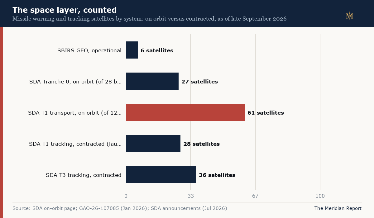
The space-layer census, tracked
This census changes with every launch, so it is maintained as a standing record rather than a one-time count. The Space Development Agency's own on-orbit page is the primary source, the page is checked against it and the agency's news page several times a day, and every change is dated here.
| Date | Census | Source |
|---|---|---|
| 24 September 2026 | 27 Tranche 0 on orbit; 61 of 126 Tranche 1 transport on orbit; T1 tracking (28) and T3 tracking (36) contracted, none launched | SDA on-orbit page; GAO-26-107085 |
| 16 July 2026 | Third Tranche 1 launch completes, more than 60 transport satellites on orbit | SDA announcement |
| 13 July 2026 | Tranche 3 tracking contracts awarded: 36 satellites, L3Harris and Sierra Space, in support of Golden Dome | SDA; trade press |
| 28 January 2026 | GAO reports 27 Tranche 0 satellites launched and seven Raytheon tracking spacecraft removed from Tranche 1 | GAO-26-107085 |
Reading the map
Three facts emerge when the layers are laid side by side.
The first is that the architecture is a set of blind spots, each layer watching the gap the others leave. The arrays see high and far but not low; the NWS sees low but short; the over-the-horizon radars coming will see low and far but coarsely; the satellites see launches and glides but not, yet, everything in between; the discrimination radars see finely but narrowly. No sensor on this map is redundant.
The second is that the map's newest pieces are its most countable. The space layer's census, six, twenty-seven, sixty-one, fourteen, thirty-six, changed this year and will change again, which is why the counts carry dates and the trackers carry the load.
The third is where Greenland sits. One base appears in three of the four layers: its array is the arc's northern first-seeing node, its modernisation is funded as the NWS-era infrastructure around it ages, and the agreement that secures it names the homeland defence programme the space layer now serves. The island is not a symbol in the architecture. It is a coordinate, and the coordinates are the part no budget line can relocate.
The map has a mirror. Russia and China maintain warning networks watching the same polar corridors from the far side, and their census, Russia's eleven site ground ring beside a possibly single surviving warning satellite, China's seven confirmed ground arrays beside its new staring constellation, is mapped and counted in the mirror article.
Our guide to how missile warning works, our radar horizon geometry, and our over-the-horizon radar explainer cover the physics behind each layer.
FAQ
How many sensors are in the North American early warning network?
Counted by system: five Upgraded Early Warning Radar phased arrays, including the UK's Fylingdales; 54 North Warning System radars across the Arctic; the Cobra Dane radar in the Aleutians; the Long Range Discrimination Radar at Clear, Alaska; sea-based X-band radar; six dedicated SBIRS satellites in geosynchronous orbit plus two hosted infrared sensors; and a proliferated layer of Space Development Agency tracking and transport satellites that had 27 Tranche 0 and 61 Tranche 1 transport spacecraft on orbit by mid 2026, with dozens more contracted. Canada's Arctic over-the-horizon radars and rebuilt lower-tier radars are joining the map before 2030.
What is the difference between missile warning and missile defence sensors?
Warning sensors detect a launch and tell people where the missile is going; defence sensors track it precisely enough for an interceptor to hit it. The early warning arrays, the over-the-horizon radars and the infrared satellites are warning and cueing systems. The discrimination radars, Cobra Dane, the Long Range Discrimination Radar and the sea-based X-band radar, exist to tell warheads from decoys so the Ground-based Midcourse Defense interceptors can be committed. The new SDA tracking layer aims to hold fire-control-quality tracks on manoeuvring weapons in between.
Why is Pituffik's radar the one node that cannot be moved?
Because of geometry, not politics. The shortest trajectories between Asia and North America cross the polar region, and a phased array at 750 miles north of the Arctic Circle looks down those corridors from above, seeing launches that mid-latitude radars cannot. No other allied territory sits under the same geometry, which is why the site has been continuously operated since 1951 and why the 2026 Greenland agreement formalises its modernisation.