
Our map of the North American early warning network ends where the missile began: five great radars, fifty four guarding the low frontier, three sorting warhead from decoy, and a space layer of 154 operational spacecraft. The map has a mirror image, and the reflection is not symmetrical. Russia and China maintain warning networks whose purpose is the same sentence with the pronouns reversed, and whose condition could hardly be more different. Russia has built one of the most complete ground radar rings on Earth and watched its satellite tier wither. China, starting later, has leapt into space while its ground tier remains smaller and partly unconfirmed.
One fact organises the whole picture. The great circle routes between the northern continents run over the pole, which means the radars that would first see a launch from North America toward Russia sit inside Russia and its closest neighbours, pointed away from the cities they protect. The same is true in reverse for the American arrays at Clear, Beale and Cape Cod. Early warning is geography before it is technology.
The ground ring that still works
The census that matters most is not a press release but a private researcher's map. Pavel Podvig, who has tracked the Russian network for two decades, published his updated count of the early warning and space surveillance radar network in August 2026, plotting eleven site markers across the country. Eight Voronezh class radars are operational: the VHF array at Lekhtusi near Saint Petersburg, two UHF arrays at Armavir in the south, the Kaliningrad radar at Pionersky, the VHF array at Mishelevka near Irkutsk, and the arrays at Yeniseysk, Barnaul and Orsk. Two more Voronezh radars, at Vorkuta and Olenegorsk, are listed as under construction, and the older Soviet era Daryal at Pechora completes the count. A separate space surveillance radar, Razvyazka at Chekhov, joined the network in the summer of 2023.
The Voronezh class is the heart of it. These are prefabricated modular phased arrays that go from foundation to operations in months rather than the years their Soviet predecessors demanded, watching out to a horizon range of about 6,000 kilometres and tracking hundreds of objects at once. Russian statements claim detection of a football sized object at 8,000 kilometres for the UHF variant, a claim that belongs to the manufacturer rather than to verified test data, but the class's job needs no embellishment: it sees ballistic objects rising over the horizon in time for a national command authority to decide something about them.
Four of these sites face the corridor that matters for North America. Olenegorsk sits above the Arctic Circle in Murmansk oblast; Pechora's giant Daryal has watched the northern horizon since the 1980s; Vorkuta, at 67 degrees north, is the new building; Mishelevka covers the far eastern approaches. Two more arrays, at Yeniseysk and Lekhtusi, contribute coverage of northern horizons from inland positions. Taken together with the Belarus based Volga radar on Russia's southeastern flank, the ground network spans the country's threat horizon in every direction, which is precisely what it was designed to do. The ring is old strategy executed in new concrete, and unlike the satellite tier it has kept working throughout.
It has also been shot at. Ukrainian drones struck the Armavir complex in May 2024, and Podvig's August 2026 update notes that it is not known whether the site's two radars resumed full operation after the strike. An attack the same week on the Orsk array left its status unclear. By August 2026, satellite imagery showed the Kaliningrad Voronezh radar covered in anti drone netting, a textile answer to a drone problem that no Cold War designer imagined. A warning network built to see intercontinental missiles is being defended against weapons that cost a few thousand dollars, and the photographs of the netting are the first such imagery of a strategic radar in history.
The constellation that withered
Russia's space tier tells the opposite story. The Tundra satellites, known to the programme as the Unified Space System, were designed to replace the Soviet Oko family in highly elliptical orbits, watching for the hot plume of a missile launch against the cold of space and relaying warning to ground command posts. Six flew between November 2015 and November 2022 on Angara boosters from Plesetsk, four short of the ten the programme once promised by 2024. Sanctions, programme delays and the Russian space industry's troubles since 2022 have meant no seventh launch has flown as of late September 2026.
What remains is thin. Public orbital analysis published in December 2025 tracked the manoeuvre history of the three most recently launched satellites and concluded that possibly only one, Cosmos 2552, was still functioning. Cosmos 2541 had shown no orbit correction since March 2025, and Cosmos 2563 appeared to have failed after its last successful manoeuvre that July. Russia's planned geostationary early warning component, the tier the United States has operated continuously for fifteen years, has never flown. A network with eleven ground radars and possibly one functioning warning satellite has depth in concrete and fragility in orbit, and the asymmetry says something honest about the Russian space industry in the 2020s: what can be built on Earth is being built, and what must survive orbit is not.
China's leap from the ground up
China entered the 2020s with no operational space based missile warning at all, a legacy 1970s era pair of giant ground arrays, and a doctrine that did not need better. Assured retaliation, the posture of a small survivable force, has no real time warning requirement. The doctrine has changed faster than the sensors can be listed. The People's Liberation Army is moving toward what Chinese sources call early warning counterstrike, authorising a retaliatory launch once an attack is confirmed in flight but before impact, and the sensor architecture has been rebuilt around it.
The command structure hardened in the 2024 reforms: the Aerospace Force now runs military space operations, with an early warning base headquartered at Lintong near Xi'an, known as Base 37, fusing satellite detections and ground radar tracks into a single threat picture, and the Xi'an satellite control centre, Base 26, flying the platforms. Open source analysts, drawing on Chinese academic publications and commercial imagery, count seven large phased array radars confirmed enough to map. The principal site is at Jiamusi in Heilongjiang province, where a thirty metre X band array entered service in 2016 and, alongside an earlier P band companion, faces the North Pacific and Arctic approaches, the primary trajectory between North America and China. Others stand at Korla in Xinjiang, in Shandong, on the Jiangsu coast and inland at Jinan, with the status of the old Xuanhua site near Beijing uncertain and a Yunnan array reported but unconfirmed.
The space tier is where the leap shows. Chinese early warning satellites fly under the cover designations of the Tongxin Jishu Shiyan experimental series, referred to in open sources by the name Huoyan, fire eye. Five are assessed to be in geostationary orbit, built around infrared payloads from the Shanghai Institute of Technical Physics. One of them, the spacecraft launched in August 2021, sits in a western hemisphere slot that gives it a persistent stare at North America. The Pentagon's December 2025 report to Congress states the capability in one sentence: Chinese satellites can reportedly detect an incoming ICBM within 90 seconds of launch, with an alert at a command centre minutes later. The word reportedly is doing real work in that sentence, as the report's own hedging, but the direction of travel is not in doubt, and it runs through a Russian handshake. President Putin said in October 2019, at the Valdai club's plenary session, that Russia was helping its Chinese partners create a missile attack warning system, and that only Russia, China and the United States would then possess such systems. Neither government has ever said what the assistance consisted of.
The corridor, side by side
The census, on one chart, shows two networks built in opposite orders. Russia matured its ground ring over two decades and let its satellite tier decay to a single possible survivor. China fielded a staring geostationary satellite over the Americas within five years of beginning the programme and has confirmed ground arrays numbering in single figures, several of them in terrain that commercial imagery can watch but public documents cannot describe.
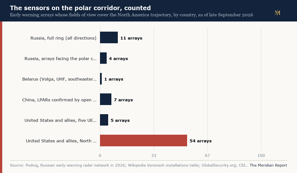
The comparison's limits are as instructive as its numbers. The populations are not equivalent: the American count is a purpose built layered architecture for warning and interception; the Russian ring is a complete national perimeter first and a North America facing subset second; the Chinese arrays are a rising tier whose true operating status is the least publicly established of the three. What is equivalent is the physics. Every trans polar trajectory crosses the same latitudes twice, once under each side's gaze, and both Russia's polar wall and America's Clear and Thule arrays were built on that shared geometric fact. A missile's warning time belongs to whoever sees it rise.
What the mirror cannot show
Three things the public record cannot establish belong in the open. First, intent and aim: neither Russia's arrays nor China's are pointed at American territory in any operational sense, they watch the air over the pole and the Pacific for whatever enters it, and the fact that they would see an American launch is a property of geometry, not of targeting. Second, status: the Russian satellite census rests on orbital behaviour, a strong method but an inference, and the operating condition of several Russian sites, including whether Armavir's radars returned to service and whether the Olenegorsk Dnepr still runs, is not publicly confirmed. Third, China's numbers: the seven radars are the count open sources will support, and the satellites' capabilities beyond the American report's single hedged sentence are assessed, not documented.
The record does establish the strategic consequence, and it is uncomfortable in both directions. Analysts of the Chinese architecture note that the same radars and networks that provide nuclear warning also serve conventional surveillance, which means a conventional attack on those dual use sensors could be read in Beijing as the opening of a disarming strike, and that China's young warning enterprise lacks the decades of procedural scar tissue that keep American and Russian officers from treating a sensor artefact as a launch. The Golden Dome programme and the sensor arc NORAD is rebuilding around Greenland answer the American side of that problem with more layers. The Russian and Chinese networks answer their side with fewer satellites, more ground and, in Beijing's case, a partner's help. Three networks now watch the same polar corridor, each certain of what the others would see, and each relying on the others' operators remaining as cautious as their own.
The ground rings are the stable fact in all of it. Radars, whether Russian Voronezh arrays or American upgraded early warning radars, are fixed, visible, documented infrastructure that a researcher can census from open sources, as the census above has done. Satellites change monthly, their health is inference, and their owners publish little. Which means the most durable observation in this census is also the simplest: whatever happens to constellations, the arrays on the ground, from Olenegorsk to Clear to Jiamusi, are not going anywhere, and the corridors they watch are the same corridors. That is the map. The launch tiers on either side of it are the story that will keep changing, and the tracker of the American space layer follows those changes. The mirror census here is maintained the same way, against Podvig's blog, the Tundra launch log and the open Voronezh site record, so a seventh Tundra designation, a radar census update or confirmation on Armavir or Olenegorsk changes this page's numbers the day the record moves.